Pennsylvania’s “Grand Canyon” Shows Autumn Splendor From Space
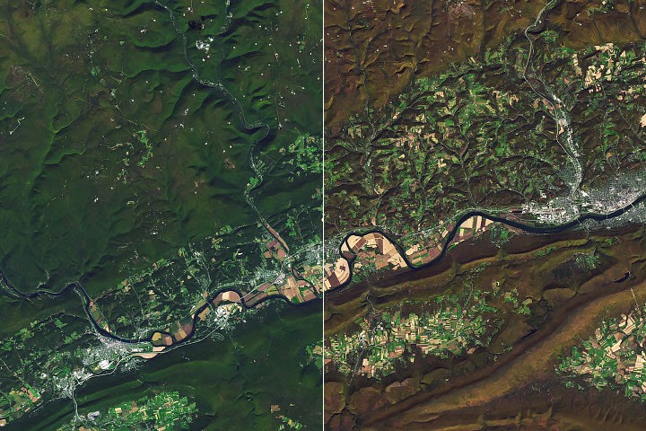
NASA’s Landsat 8 captured the fiery fall colors of Pine Creek Gorge, the 1,500‑foot‑deep canyon nicknamed the Grand Canyon of Pennsylvania.
Satellite View Captures Fall Colors
The Operational Land Imager (OLI) aboard NASA‑USGS Landsat 8 recorded Pine Creek Gorge on October 25, 2026, when the foliage was ablaze with reds and golds. The image shows the gorge’s approximately 1,500 feet (460 meters) depth and its gently curving path through the forests of the Allegheny Plateau.
How Glaciers Shaped the Canyon
During the last ice age, glaciers advancing from the northeast dammed Pine Creek, filling the valley with lakes. When those lakes overflowed, water began flowing south, a reversal from the river’s pre‑glacial northward course. As the ice receded, the river was entrenched in its new southward path, and sediment left by the meltwater helped prevent a return to the north. Continuous glacial meltwater further deepened the valley into the form seen today.
From “Pennsylvania Desert” to Forest Revival
In the early 19th century, loggers harvested the massive white pines, hemlocks, and hardwoods that once covered the gorge’s slopes, using the trees for ship masts and leather tanning. Logs were floated down Pine Creek to the Susquehanna in massive drives before railroads arrived. By the early 20th century, decades of logging left the area so barren it earned the nickname “Pennsylvania Desert.”
Since then, the forest has regenerated, now dominated by northern hardwood, mixed oak, hemlock, and white pine. The resurgence supports wildlife such as black bears, coyotes, bobcats, timber rattlesnakes, and a variety of songbirds. In 1968, a 30,000‑acre (12,000‑hectare) portion of the gorge was designated a National Natural Landmark.
Visiting the Gorge
Visitors can experience the scenery from several state parks, including Colton Point State Park, and from the Pine Creek Rail Trail that follows the gorge’s floor. The seasonal transformation is evident in Landsat images taken on October 9, 2026 (left) and October 25, 2026 (right), illustrating the rapid shift in foliage color.
Data and Credits
All satellite imagery is from Landsat 8’s OLI sensor and processed by NASA Earth Observatory. The photographs are credited to Michala Garrison (NASA Earth Observatory) and fishhawk (Flickr). The story was written by Lindsey Doermann.