October Model Update Shifts Snowfall Outlook for Winter 2026/2027
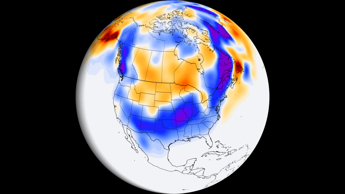
New October runs of six seasonal models show more snow for the southern and central U.S. and less for the north, driven by a strong Super El Niño.
Super El Niño Dominates the Seasonal Signal
The latest October data from six seasonal models converge on a clear Super El Niño footprint for Winter 2026/2027. More snow is projected across much of the southern and central United States, while the northern United States, southern Canada, and most of Europe see reduced snowfall.
Timing of the Snow Season
All models agree on a slow start in December, with the strongest snowfall signal arriving in the second half of the winter and likely persisting into early spring. The timing matches a classic Super El Niño signature.
Regional Shifts from September to October
The ECMWF change map illustrates where the October run diverges from September. Blue shading marks areas gaining snow, brown shading marks losses. The southern and central United States show the most pronounced increases:
Ohio Valley and Central Midwest: about +2.7 inches
Southern Plains and Texas: about +2.0 inches
Southwest and Southern Rockies: about +1.5 inches
In the Northeast, the latest run adds snow, especially in Maine, New Hampshire, and Vermont, while the Northern Plains, Upper Midwest, and parts of Montana and Wyoming lose snow.
Canadian Adjustments
Canada’s outlook gains snow over Quebec (+6.7 cm), British Columbia, and Atlantic Canada. The Prairies and Ontario experience modest losses compared with September forecasts.
European Outlook Weakens
Europe sees a general reduction in snowfall in the October run, with the largest drops across the southern and central regions.
Underlying Ocean Conditions
NOAA CRW data show significant El Niño warm anomalies in the tropical Pacific, with peak ocean anomalies exceeding 7 °C (12.6 °F) above normal across a broad area. Such a magnitude is expected to influence seasonal patterns well into spring 2027.
How Super El Niño Translates to Snow
Strong El Niño events typically extend the Pacific jet stream, lower pressure, cooler temperatures, and increase moisture over the southern United States. When cold air is present, this combination can boost snowfall potential across the central, southern, and eastern United States.
A composite of past moderate and strong El Niño winters shows above‑normal snowfall (blue) in the Sierra Nevada, Four Corners, Southern Rockies, parts of the Central Plains, and the South and eastern United States, while large deficits (brown) appear in the Pacific Northwest, Great Lakes, and Northeast due to a Canadian high‑pressure anomaly that limits cold‑air intrusions.
Historical Reference: 2015/2016 Super El Niño
During the 2015/2016 Super El Niño, a post‑Christmas blizzard dumped 20‑30 inches of snow in eastern New Mexico, with drifts up to 6‑10 feet closing Interstate 40 from Albuquerque to Amarillo. In January 2016, a historic nor’easter delivered heavy snowfall along the East Coast, affecting over 100 million people, with nearly 24 million receiving more than 20 inches.
Tools for Readers
The article includes a full set of snow maps, a comparison of September versus October forecasts, and a Snowfall Explorer that lets users check detailed projections for any state, province, region, or country in the United States, Canada, and Europe.